Friday, October 28, 2005

Cardiff Professor questions the reason for late Roman Britain gold hoards

MORE Roman gold is found in Britain than anywhere else - and now a Welsh academic has come up with an intriguing theory explaining why.

Thousands of gold and silver artifacts from the Roman period, especially when the conquerors finally left these islands in the 4th and 5th centuries.

Dr Peter Guest, of Cardiff University's School of History and Archaeology, is the leading expert on the biggest ever Roman gold treasure discovered in Britain. In 1992, 15,000 gold and silver coins were found at Hoxne in Suffolk in 1992.

Dr Guest explained that the gold mostly comes from a 50-year period towards the end of Roman occupation.

He said, "Before then, Britain is not very special, but in that 50-year phase, which coincides with the end of Roman control, lots of stuff is found.

"It normally consists of gold jewellery, spoons, toothpicks, thousands of coins and other items. I think connected to the fact that the Roman administration in Britain stops around 400 to 410 and the fact that the separation Britain experienced from the Roman Empire would have been so sudden.

"We had been part of the Empire for 350 years by that time, which is a very long time.

"It happened very suddenly and it might have been quite violent and one of the reasons for the huge amount of gold and silver is related to this separation.

"People weren't able to leave Britain and move somewhere else or weren't able to reuse it and recycle it and for some reason it has just stayed there." A theory already exists that people buried the treasure because of invasion from the Angles and Saxons of northern Germany.

Dr Guest said, " It is based on the Angles, Saxons and German groups coming over via the North Sea conquering eastern England, forcing all this gold and silver to be buried .

"The reason for that would have been people were being forced into slavery or killed.

"I think there is an element of truth in that but to blame the collapse of Roman gold on the Saxons is unfair. They wanted to come over here and live like the Romans, there was no point in them destroying everything.

"We need to be more careful and sophisticated in the way we approach this. The period we are looking at was known as the Dark Ages, there is very little archeological or historical evidence from the time."

Divers find image of Gladiator in G-String

The Teesdale Mercury: "AN image of a Roman gladiator wearing only a G-string has been dug from the bed of the River Tees.

Broken Roman pottery, decorated with the picture, was recovered from the river at Piercebridge.
Archaeologists believe the figure of a gladiator, who also appears to be holding a whip, may be the first of its kind ever discovered."

Thursday, October 20, 2005

Remanants still remain of the battle of Mons Graupius

Sunday Herald: "THE dawn of Scottish history began with a battle on an Aberdeenshire hill in 84AD. On one side of the 
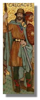
field were the vast legions of the mighty Roman Empire. On the other, a 30,000-strong confederate army of Caledonians ? our Scottish ancestors. This encounter, which became known as Mons Graupius, was a key moment for the Romans in their almighty struggle to conquer the whole of Britain. For the Scots, it was a battle for survival against a brutal occupation.


?Robbery, butchery, rape: the liars call it Empire,? roared Calgacus, leader of the Caledonians, at the men gathered before him. ?They create a desolation and call it peace. Whether you are to endure slavery forever or take summary vengeance, this field must decide.?

In the event, Calgacus and his brave warriors marched into a defeat at the hands of General Agricola, the Roman leader. The legions forced their adversaries to melt away into the great forest . But the Caledonians? fate would not be decided that day, as Calgacus had believed. Although the Romans won at Mons Graupius, they would never win the war against Scotland.

We should, nonetheless, be grateful that Rome decided to invade this remote corner of Europe. Had the Empire failed to penetrate so far north following the initial conquest of south Britain in around 43AD, we would know next to nothing about the natives. Calgacus ? whose name means ?swordsman? ? is, after all, the first Scot in recorded history.

His identity, and virtually all that we know about our early forebears, was recorded for us by Tacitus ? historian of the Roman campaign in Britain (and Agricola?s son-in-law). What Tacitus tells us should not be taken at face value. He aimed to write a glowing biography of Agricola and use his talents as a rhetorician to criticise Rome. He put noble words in Calgacus?s mouth to contrast the freedom-loving, uncorrupted Caledonians with the slavery of the south Britons, tainted by the vice, greed and arrogance of an autocratic empire, which Tacitus considered to have fallen after the golden age of the republic.

Mons Graupius should have been the beginning of a long haul to conquer the Caledonians. But instead, Agricola marched south to winter quarters. With reinforcements required on the Rhine and Danube, the Romans were obliged to give up on Scotland and withdraw to bases in safer southern territory. "


The remnants of the mightiest marching-camp in the northeast ? with space for 30,000 men ? can be found at Logie Durno, adjacent to Bennachie hill, near the field where Mons Graupius was probably fought. Enduring as their ghostly outlines are, however, these were not permanent garrisons and attempts to build such had to be aborted.

For more information about Calgacus, see Famous Scots

Ancient Roman town of Claterna uncovered near Bologna

ANSA.it : "The once bustling Roman town of Claterna is slowly re-emerging from the soil 15 centuries after it was abandoned and then vanished beneath farmland .

As a result of haphazard excavations in the past, the remains of a few patrician homes have been uncovered at the site near Bologna, along with mosaics and some pottery shards .

But a methodical, long-term research project is now getting under way for the first time ever, with funding from regional and provincial authorities, which have acquired the site .

So far digs have uncovered small portions of the town, revealing the street layout and mosaic paving from homes. Archaeologists have also found pottery, coins, metalwork and decorated bone .

An Etruscan-Celtic settlement stood in the area prior to the arrival of the Romans, who founded Bononia (Bologna) in 189 BC before spreading out to the surrounding area .

Claterna took its name from the river that still runs in the area today, the Quaderna, a clue that helped archaeologists identify the Roman ruins .

In fact, while Claterna's precise location was a mystery, historians had long known of its existence from various documents and maps .

A careful study of local place names, combined with the large number of Roman finds being unearthed by farmers, led experts to place Claterna between Bologna and Imola .

The town's prominence in ancient times was partly due to its location, at a crossroads between the ancient Roman highway of Via Aemelia, now the Via Emilia, and an important route across the Apennines, which archaeologists believe was probably the Via Flaminia Minor .

Both roads, constructed as consular routes in 187 BC, were major highways in Roman times, ensuring Claterna a constant flow of visitors, who brought with them trade, business and cash."

Associations appeal for new archaeological site in Morocco to be saved

Archeology : Associations appeal for new archaeological site to be saved :: moroccoTimes.com: "

When founded by the Phoenicians in the 6th century BC, Dhar Asekfane in Morocco overlooked a marshy zone near a river leading to the nearby coast. This is a typical choice of the Phoenicians, who looked for dominant locations with easy access to the interior for their agricultural and trading contacts with the local people combined with a navigable river, explained the archaeologists working on an excavation of the site.

The local Mauretanians followed the Phoenicians from the 5th-2nd century BC. Towards 40 BC, the Romans took over, staying until the 5th century AD. Coins and ceramics indicate a Moslem presence from the 12th-13th century AD.

The excavations, going down 60 cm, have brought to light well-preserved Roman remains: pottery, coins, large jars, thermal baths with changing room and cold, tepid and hot rooms. Also revealed was a group of fish-salting basins, supplied by large water reservoirs.

During the Roman occupation, the site was fortified by an impressively wide rampart. The main entry to the city was on the south face of the rampart, which contained several towers. "

Berlin Museum to Restore Famed Roman Gate


ABC News: "Officials from Berlin's Pergamon Museum announced plans Wednesday to dismantle and remove much of its famed Market Gate of Miletus over the next year and a half and to spend the next 10 years restoring it.

The towering Roman gate, built around 120 A.D. as the entrance to the market square in the Aegean coastal city of Miletus in what is now Turkey, is one of the museum's chief attractions. But metal supports built decades ago are sagging dangerously.

In the next three weeks, workers will cut a hole in the 75-year-old museum's southern exterior wall. Through it, they will pass 58 of the gate's marble blocks weighing about 110 tons to load them onto flatbed trucks and take them to an offsite facility for restoration.

The entire project is expected to take about 10 years and cost about $60 million, according to Gisela Holan, who oversees reconstruction work on the Pergamon and the four other museums that collectively make up Berlin's Museum Island.

The museum plans to put up a transparent wall that will contain dust and noise but let visitors continue to view the gate. Peter-Klaus Schuster, city museum director, said the unique setup will help make the Pergamon an 'academy of restoration work.'"

An ancient map of Rome that's surprisingly up to date

Glad to see my own University's Nolli Map Project is finally getting a little more press. I met with Dr. Tice and offered to provide images for the project.

"In 1748, architect and surveyor Giambattista Nolli completed a map of his hometown. The Pianta Grande di Roma ("Great Plan of Rome") was built from 12 minutely detailed copper plates, covered six by seven feet in its assembled state, and was so accurate that it continued to be used as the basis for government maps of the city until the 1970s. In 2005, a team at the University of Oregon brought the map online in order to "create and implement an innovative and highly interactive website and teaching tool for the study of the city of Rome." It may be a wordy mission statement, but the University of Oregon team certainly met its goals - The Interactive Nolli Map Website offers a good deal more than just a new look at an old map.

When created, the "Great Plan" was not only an impressive scientific and artistic achievement, it also set some cartographic precedents that are still followed today - such as Nolli's choice of the ichnographic, or plan, style of illustration rather than the more popular "bird's eye view." Nolli's was also the first map to use dark shades to mark buildings and private spaces and light shades for streets and public spaces, and the first such chart oriented so that North, rather than East, was at the top of the page. (In fact, the phrase, 'to orient' oneself, comes down from the earlier practice of placing the East at the top of maps.) Now, in its interactive incarnation, the map continues to set new precedents, as it folds history, cartography, urban design, and even architecture into a single presentation."

Friday, October 14, 2005

Carnegie Mellon Grant funds Roman and Medieval Research

Two years ago, Harvard's Goelet Professor of Medieval History Michael McCormick was awarded $1.5 million as part of a grant from the Mellon Foundation in New York.

McCormick asked for a two-year deferment and has since been planning a series of interdisciplinary projects?including researching isotopes and teeth, making old Latin texts accessible, and starting a summer internship program?which he will begin to execute this year.

McCormick said. ?The other things the grant will fund include launching a program to study isotopes and DNA of my Roman and medieval skeletons....I?m also trying to convince the University to help me create an undergraduate internship in medieval archaeology in Oxford, starting next summer.?

McCormick said he wants to make research into medieval life an interdisciplinary project. Speaking of a project involving the study of ancient Roman teeth, McCormick said, ?We?re planning on bringing together historians, economists, archaeologists, natural scientists, and bone specialists.?

He said they plan on studying the ancient Romans? diet, health, DNA, and the diseases they may have suffered.

Darryl J. Campbell ?06, one student already working with McCormick, said he is focusing on the Computative Philology Initiative, for which he helps scan old Latin texts and makes them legible. Campbell said his group hopes to compile Latin texts that are not available to the public and build a library that would be freely accessible to all.


A recent lecture led by Thomas Calligaro, the head physicist of the world-renowned Louvre Museum, and Peter Perin, the director of the French Musee d?Archeologie Nationale, also funded by the grant?focused on the duo?s discoveries of a link between India and France in the 6th century.

Calligaro and Perin said that by using a fusion of physics and history, they were able to determine that garnets with which a French queen was laid to rest had Indian origins. The garnets were set in cloisonne, and French garnets rarely are set that way. Perin traced its origins and Calligaro employed particle induced x-ray emission, or PIXE, a technique that accelerates particles, to discern the elements in the different garnets by their movement. Because garnets of different elements are found in different locations, the researchers were able to conclude that they, indeed, were of Indian origin.

Friday, October 07, 2005

The Solarium of Augustus to be Recreated in Eugene Oregon


Physorg.com: "Historian John Nicols and physicist Robert Zimmerman have joined with architects James Tice and Virginia Cartwright to lead a group of scholars and students seeking to create a replica of the Horologium / Solarium of Augustus, a 60-foot granite obelisk erected at Heliopolis in the seventh century B.C. by Psammetichus II and brought to Rome by Augustus in 10 B.C. The obelisk was to be used as the 'gnomon' (the staff against which the shadow is projected from the sun to the ground) of a new solar calendar and 'clock.'

'It was a momentous event in the history of time, for it marks the revolutionary shift in time-keeping from the lunar to a solar-based system we now use,' said Nichols, who specializes in ancient history and the history of science.

'What makes the Augusti solarium so significant is that it was the first attempt in the West to display the hours of the day and the days of the month - as well as the months and the seasons - in an astronomically correct way. Previous calendars were based primarily on the lunar cycle which created a 355-day year.'

The obelisk was toppled in late antiquity, rediscovered in the Renaissance, and set up again - without the face of the dial - in front of the Italian Parliament in Rome. About 20 years ago, a team of German archaeologists located the 'face' of the sun, which measures roughly 300 by 200 feet, 18 feet below the current street level of Rome. Nicols said the scholars and students hope to lay out the gnomon, or obelisk, for the solarium on a half-scale model. Hours of the day, days of the month, and the seasons will all be clearly marked."

I met with Professor Tice about participating in the Nolli Map Project. I didn't realize he was also working on this endeavor. When it is completed, I'll have to grab my digital camera and go have a look!

See the project website: http://darkwing.uoregon.edu/~klio/solarium/images.htm

Lavish Byzantine Mansion unearthed near Caesarea


The remains of a lavish Byzantine mansion with pictorial mosaic flooring and a rare table with gold-encrusted glass platelets have been uncovered in the coastal city of Caesarea during an archaeological excavation, Israel's Antiquities Authority announced Monday.

The 16 X 14.5 meter rectangular colorful mosaic -- part of the main central courtyard of the palace -- located just off the shorelines of the Mediterranean Sea, had been buried under sand dunes for the past 50 years, since 1950, when an Israeli army unit undergoing
training in the area accidentally stumbled on a section of the impressive mosaic flooring when digging trenches, excavation director Dr. Yosef Porat said.

According to the director of the excavations, the 6th century mansion likely belonged to one of the richest Christian families in Caesarea, possibly the aristocracy, although no inscriptions have been found
at the site to date.

The palace was destroyed by fire near the end of the Byzantine Period (324-638 CE) when the Arabs conquered the strategic harbor city, and set fire to any building outside the city walls, he said.

The mosaic-lined courtyard is composed of a series of animals, including lions, panthers, wild boars, dogs elephants, antelopes, and bulls, all enclosing 120 medallions, each of which contains a single bird, causing archaeologists to dub it "the bird mosaic."

During the excavations surrounding the central courtyard, archaeologists uncovered a unique table inlaid with a checkerboard pattern of gold-encrusted glass platelets in various shapes. Each square glass platelet in the table, which was found lying
upside-down on the pavement, bears a flower or cross stamped into the platelet after its production was completed, an unusual process that required reheating the glass. "